
Tack för att du stödjer denna webbplats ❤️
Donera
Donera
Topografisk karta Monviso
Klicka på kartan för att visa höjden.
Tack för att du stödjer denna webbplats ❤️
Donera
Donera
Monviso
Monte Viso is the location of a Neolithic jadeite quarry, at an elevation of 2,000 to 2,400 metres. Its productivity peaked around 5000 BC. The jadeite was used to make cult axes, which are found all over western Europe. One such ceremonial axe head was found as far away as a small hill called Tristia in Western Ireland and is on display in the National Museum of Ireland – Archaeology, Dublin.
Tack för att du stödjer denna webbplats ❤️
Donera
Donera
Om denna karta
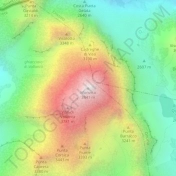
Namn: Topografisk karta Monviso, höjd, relief.
Plats: Monviso, Pontechianale, Cuneo, Piedmont, Italy (44.66739 7.08994 44.66749 7.09004)
Medelhöjd: 2 985 m
Minsta höjd: 2 385 m
Maxhöjd: 3 831 m
Tack för att du stödjer denna webbplats ❤️
Donera
Donera