
Tack för att du stödjer denna webbplats ❤️
Donera
Donera
Topografisk karta Col de l'Iseran
Klicka på kartan för att visa höjden.
Tack för att du stödjer denna webbplats ❤️
Donera
Donera
Col de l'Iseran
On both sides of the Col de l'Iseran, mountain pass cycling milestones mark the distance to the summit, the current altitude, and the average slope in the following kilometre.
Tack för att du stödjer denna webbplats ❤️
Donera
Donera
Om denna karta
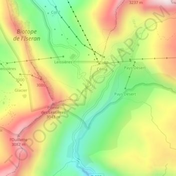
Namn: Topografisk karta Col de l'Iseran, höjd, relief.
Medelhöjd: 2 779 m
Minsta höjd: 2 467 m
Maxhöjd: 3 117 m
Tack för att du stödjer denna webbplats ❤️
Donera
Donera
Andra topografiska kartor
Klicka på en karta för att se dess topografi, dess höjd och dess relief.