
Donera
Topografisk karta Alastaro
Klicka på kartan för att visa höjden.
Donera
Om denna karta
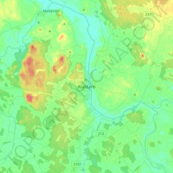
Namn: Topografisk karta Alastaro, höjd, relief.
Medelhöjd: 80 m
Minsta höjd: 62 m
Maxhöjd: 118 m
Donera
Andra topografiska kartor
Klicka på en karta för att se dess topografi, dess höjd och dess relief.
Turku
Operational since 1955, the city's weather station is located at an altitude of 47 metres (154 feet) at Turku Airport. The weather in the city itself is affected by the proximity of the sea, so the wintertime temperatures are often milder than those measured at the airport. The moderating impact of the sea…
Medelhöjd: 32 m
Donera
Donera
Turku
Operational since 1955, the city's weather station is located at an altitude of 47 metres (154 feet) at Turku Airport. The weather in the city itself is affected by the proximity of the sea, so the wintertime temperatures are often milder than those measured at the airport. The moderating impact of the sea…
Medelhöjd: 32 m
Donera
Donera
Donera
Donera
Turku
Operational since 1955, the city's weather station is located at an altitude of 47 metres (154 feet) at Turku Airport. The weather in the city itself is affected by the proximity of the sea, so the wintertime temperatures are often milder than those measured at the airport. The moderating impact of the sea…
Medelhöjd: 32 m
Donera