
Donera
Topografisk karta Migliana
Klicka på kartan för att visa höjden.
Donera
Om denna karta
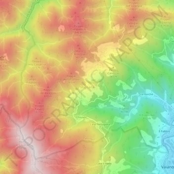
Namn: Topografisk karta Migliana, höjd, relief.
Medelhöjd: 589 m
Minsta höjd: 150 m
Maxhöjd: 971 m
Donera
Andra topografiska kartor
Klicka på en karta för att se dess topografi, dess höjd och dess relief.
Prato
Prato (/ˈprɑːtoʊ/ PRAH-toh; Italian: [ˈpraːto] ) is a city and municipality (comune) in Tuscany, Italy, and is the capital of the province of Prato. The city lies in the northeast of Tuscany, at an elevation of 65 metres (213 ft), at the foot of Monte Retaia (the last peak in the Calvana chain). With…
Medelhöjd: 148 m
Donera