
Tack för att du stödjer denna webbplats ❤️
Donera
Donera
Topografisk karta Oreshek
Klicka på kartan för att visa höjden.
Tack för att du stödjer denna webbplats ❤️
Donera
Donera
Om denna karta
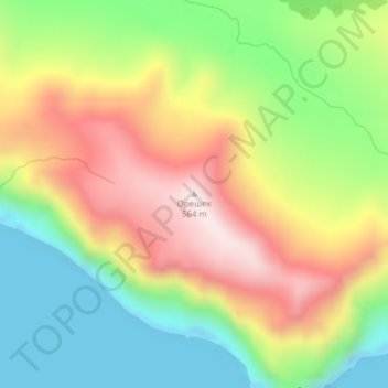
Namn: Topografisk karta Oreshek, höjd, relief.
Medelhöjd: 253 m
Minsta höjd: -11 m
Maxhöjd: 558 m
Tack för att du stödjer denna webbplats ❤️
Donera
Donera
Andra topografiska kartor
Klicka på en karta för att se dess topografi, dess höjd och dess relief.
Urup
Russia > Sakhalin Oblast > Kurilsky District
Nicolson, energetic and thorough, initiated a hydrographic survey, ordered topographic observations, and named prominent points. The central event during their stay at Urup was the annexation on 2 September 1855. Details of the proceedings, preserved in Nicolson's dispatch, highlighted the allies' declaration…
Medelhöjd: 54 m