
Tack för att du stödjer denna webbplats ❤️
Donera
Donera
Topografisk karta Duncormick
Klicka på kartan för att visa höjden.
Tack för att du stödjer denna webbplats ❤️
Donera
Donera
Om denna karta
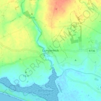
Namn: Topografisk karta Duncormick, höjd, relief.
Medelhöjd: 15 m
Minsta höjd: -2 m
Maxhöjd: 43 m
Tack för att du stödjer denna webbplats ❤️
Donera
Donera
Andra topografiska kartor
Klicka på en karta för att se dess topografi, dess höjd och dess relief.
Taghmon
Ireland > County Wexford > New Ross Municipal District
Many Irish place names are topographically descriptive, and 'Achadh Liathdrom' is no exception. From the western side of the Forth Mountain, as it slopes down towards Ballintlea, a succession of gradual hills and valleys undulate their way across this part of County Wexford towards Camross, Bree and…
Medelhöjd: 67 m
Tack för att du stödjer denna webbplats ❤️
Donera
Donera
Tack för att du stödjer denna webbplats ❤️
Donera
Donera
Tack för att du stödjer denna webbplats ❤️
Donera
Donera
Tack för att du stödjer denna webbplats ❤️
Donera
Donera