
Tack för att du stödjer denna webbplats ❤️
Donera
Donera
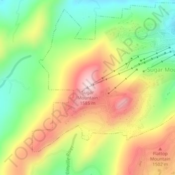
Topografisk karta Sugar Mountain
Klicka på kartan för att visa höjden.
Tack för att du stödjer denna webbplats ❤️
Donera
Donera
Sugar Mountain
Sugar Mountain is a mountain in the North Carolina High Country and wholly in the Pisgah National Forest. Its elevation reaches 5,236 feet (1,596 m) and is split along the Eastern Continental Divide, generating feeder streams for the Linville, Elk, and North Toe rivers. On its north slope resides the Village of Sugar Mountain.
Tack för att du stödjer denna webbplats ❤️
Donera
Donera
Om denna karta
Namn: Topografisk karta Sugar Mountain, höjd, relief.
Plats: Sugar Mountain, Avery County, North Carolina, United States (36.12452 -81.87572 36.12462 -81.87562)
Medelhöjd: 1 385 m
Minsta höjd: 1 211 m
Maxhöjd: 1 584 m
Tack för att du stödjer denna webbplats ❤️
Donera
Donera