
Donera
Topografisk karta Montemarcello
Klicka på kartan för att visa höjden.
Donera
Om denna karta
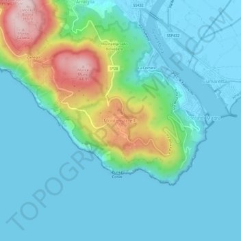
Namn: Topografisk karta Montemarcello, höjd, relief.
Plats: Montemarcello, Ameglia, La Spezia, Liguria, 19031, Italy (44.02616 9.94563 44.06616 9.98563)
Medelhöjd: 72 m
Minsta höjd: -3 m
Maxhöjd: 362 m
Donera
Andra topografiska kartor
Klicka på en karta för att se dess topografi, dess höjd och dess relief.
Cinque Terre
Italy > Liguria > La Spezia > Riomaggiore
The Cinque Terre National Park was established on 6 October 1999 in recognition of the territory's considerable scenic, agricultural, historical and cultural value. Two years before, the area was added to the list of World Heritage Sites. The five medieval towns along the Ligurian Coast provide scenic views of…
Medelhöjd: 198 m
Donera
Donera
La Spezia
Because of its topography, the city is not exposed to winds from the north, which lap western Liguria, but to those from the southeast. These may bring heavy rain and they can reach 80 kilometres per hour (50 mph), in rare cases causing the blocking of the port. The only northern wind reaching the city is the…
Medelhöjd: 143 m
Donera
La Spezia
Because of its topography, the city is not exposed to winds from the north, which lap western Liguria, but to those from the southeast. These may bring heavy rain and they can reach 80 kilometres per hour (50 mph), in rare cases causing the blocking of the port. The only northern wind reaching the city is the…
Medelhöjd: 35 m
Donera