
Donera
Topografisk karta Biacesa di Ledro
Klicka på kartan för att visa höjden.
Donera
Om denna karta
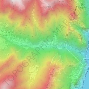
Namn: Topografisk karta Biacesa di Ledro, höjd, relief.
Medelhöjd: 831 m
Minsta höjd: 56 m
Maxhöjd: 1 638 m
Donera
Andra topografiska kartor
Klicka på en karta för att se dess topografi, dess höjd och dess relief.
Trento
Italy > Trentino – Alto Adige/Südtirol > Provincia di Trento
The municipality of Trento stretches across a wide range of altitude levels, going from just under 200 m above sea level at the city centre, to 400 m in Povo and Cognola, to 2000 m above sea level at Monte Bondone, boroughs at higher elevation, for instance Viote, have a colder alpine climate (Dw). Urban…
Medelhöjd: 789 m
Donera
Val di Fiemme
Italy > Trentino – Alto Adige/Südtirol > Provincia di Trento > Panchià
Medelhöjd: 1 640 m
Donera
Donera
Pinzolo
Italy > Trentino – Alto Adige/Südtirol > Provincia di Trento
Pinzolo (Eastern Lombard: Pinsöl) is a small town and comune situated in Val Rendena in Trentino in the northern Italian Alps at an elevation of 800 metres (2,600 ft). The Church of Saint Vigilius of Trent stands in the town.
Medelhöjd: 1 924 m
Donera
Lago di Molveno
Italy > Trentino – Alto Adige/Südtirol > Provincia di Trento > Molveno
Medelhöjd: 1 071 m
Donera
Levico Terme
Italy > Trentino – Alto Adige/Südtirol > Provincia di Trento
The town is dominated by the mountains of the Lagorai range on the north, with Monte Fronte, elevation 1,582 metres (5,190 ft), and Monte Panarotta (2,002 metres (6,568 ft)), and the zone of the Plateaus (Vezzena, Lavarone, Luserna, Folgaria) on the south, where Cima Vezzena, also locally called Pizzo di…
Medelhöjd: 952 m
Donera
Donera
Donera
Donera
Donera
San Martino di Castrozza
Italy > Trentino – Alto Adige/Südtirol > Provincia di Trento
Medelhöjd: 2 005 m
Lago di Lagolo
Italy > Trentino – Alto Adige/Südtirol > Provincia di Trento > Lagolo
Medelhöjd: 1 004 m
Donera
Donera
valle dell'Anza
Italy > Trentino – Alto Adige/Südtirol > Provincia di Trento > Levico Terme > Selva di Levico > Masi Rossi
Medelhöjd: 807 m
Donera
Donera
Trento
Italy > Trentino – Alto Adige/Südtirol > Provincia di Trento
The municipality of Trento stretches across a wide range of altitude levels, going from just under 200 m above sea level at the city centre, to 400 m in Povo and Cognola, to 2000 m above sea level at Monte Bondone, boroughs at higher elevation, for instance Viote, have a colder alpine climate (Dw). Urban…
Medelhöjd: 789 m
Donera